Miscellaneous
| ER | EarthRanger acronym that is commonly used around certain documentation. |
| Source | A device that generates sensor data in EarthRanger such as; animal collars, vehicles trackers, gps radios, etc. |
| Observations Points | Refer to recorded data or information gathered automatically from various sources such as subjects, sensors, or other monitoring devices. |
| SubjectSource assignment: | Associates a source and a subject for a specific time period. Let us re-use a collar on two different animals. |
| Source Provider: | The system that is sending data about a group of sources, for example a collar manufacturer. (Link to 100+ integrations we support) |
| User: | Someone that can access EarthRanger, these can be profiles with a login or a password, or PIN profiles that can access EarthRanger with a PIN. |
| Username | An account that requires a username and a password to enter EarthRanger. |
| User Profile | A secure account that requires a PIN to login to EarthRanger so devices can be shared with multiple members without having to log out of session. |
| DAS | Domain Awareness System, previous name of the EarthRanger system. |
| PAMDAS | Protected Area Management Domain Awareness System |
| Telemetry Data | Information transmitted by GPS or radio collars attached to wildlife, providing location and other vital statistics. |
| Geofencing | The creation of virtual boundaries or zones on a map to monitor and control wildlife movements and human activities. |
| Historical Data | Past information and records collected by EarthRanger, which can be used for trend analysis and decision-making. |
| Analytics | The process of examining and interpreting data collected by EarthRanger to gain insights and make informed conservation decisions. |
| Data Integration | The process of combining data from various sources, such as camera traps, GPS trackers, weather stations, and other software systems into a unified dataset. |
| CITES | Convention on International Trade in Endangered Species of Wild Fauna and Flora. CITES is an international agreement, signed by 184 parties in 1973, designed to ensure that international trade in animals and plants does not threaten their survival in the wild |
| IUCN Status | International Union for Conservation of Nature's Red List of Threatened Species has evolved to become the world's most comprehensive information source on the global extinction risk status of animal, fungus and plant species. |
| GIS Layers | Digital representations of geographic features and data sets that can be displayed over EarthRanger Base Maps with various aspects of information such as fences, land use, vegetation, demographics, and more. |
| Incident Management | The process of responding to alerts and incidents, which may involve dispatching rangers to investigate or take action. |
| Remote Imagery | Visual data or images captured from a distance using satellites, or other remote sensing devices. This type of imagery is obtained without direct physical contact with the object or area being observed. |
| Remote Sensing | The use of satellites or other remote technologies to collect data about the Earth's surface, often used in EarthRanger for environmental monitoring. |
Main Layout

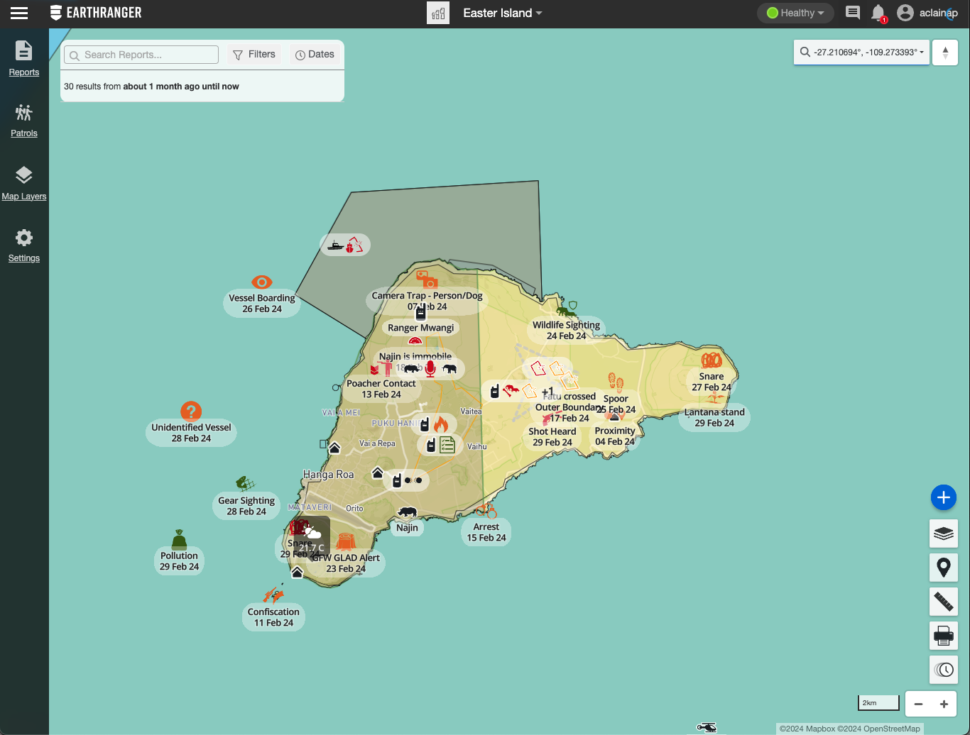
| Top Navigation Bar | Top bar that holds different functionalities. Including menu, map quicklinks, network status, alerts, notifications and user settings. |
| Sidebar Navigation | View, filter, and manage Events, Patrols, Map Features, and Settings. |
| Menu | A list of support resources, data export options, site settings, and other useful information. |
| Map Tools | This section contains the tools to personalize your experience on the EarthRanger map. |
| Coordinates | Set of numbers used to specify the location of something. Coordinates can have different formats such as DEG, DMS, DDM, UTM, MGRS. |
| Map Quicklinks | A list of user-defined links, for quick navigation between areas of interest. |
| Connection Status | Show the health of the system in real time. |
| Messages | Send messages between rangers and operation rooms when using Garmin InReach devices. |
| EarthRanger Notifications | Community announcements from the EarthRanger team about new features, system outages, and major developments. |
| User Settings | Manage users, change user profiles, or log out from the session. |
| Create | Button in the Map Tools for creating an event/patrol. |
| Base Maps | Change the main map layer type between Terrain, Topographic, Satellite, and other user-defined options. |
| Map Pin | Place a temporary marker on the map to annotate a location, copy its coordinates, or start a event or patrol from that position. |
| Ruler | Measure the distance and bearing between two or more points. |
|
|
|
| Time Slider | Scrub back and forth to visualize your map data over a time range. |
| Map Zoom | Zoom in or out on the map. |
Menu

| Alerts | Configure alerts for Events. You can select a specific notification method between SMS, email and Whatsapp message and configure alerts based on conditions selected. |
| Contact Support | Contact the Support Team to report an issue or request assistance. |
| Help Center | A website where you can find helpful information, documentation, FAQs and videos. |
| Community | A place to interact with other EarthRanger users, post questions, and share your experience. |
| User’s Guide | A link to the User Guide of EarthRanger. |
| Field events | Export a spreadsheet of the events currently filtered in the Events Feed. |
| Subject KML | Refers to a Keyhole Markup Language file that includes geographic data of the subjects in EarthRanger. This file works with a network link that references directly the data from EarthRanger. |
| Subject Summary | Export a spreadsheet detailing your site’s devices and the subjects to which they are assigned. |
| Observations | Export a spreadsheet of observations generated by subjects. |
| Server version | Indicates the server version of EarthRanger on your site. |
Settings

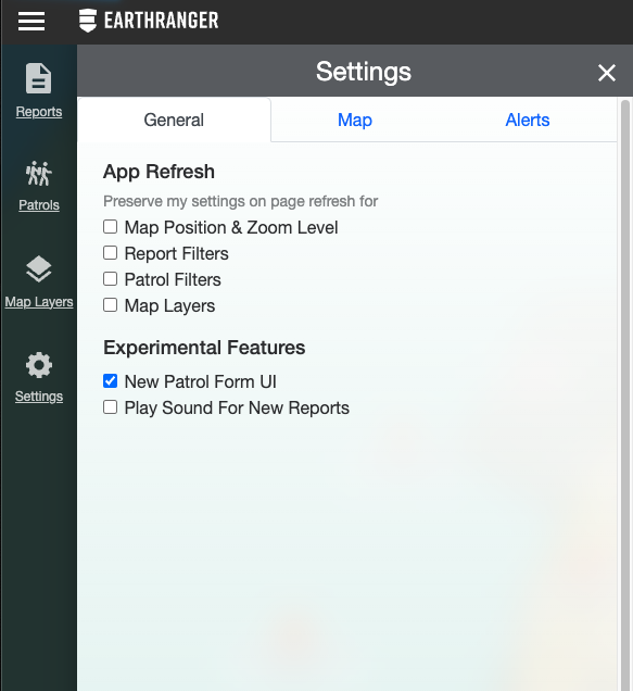
| Map Settings | Fine-tuned controls for how your data is displayed. |
| General | A general settings configuration. |
| App Refresh | When the site page is refreshed. |
| Map Position & Zoom Level | When refreshing the page, the position and the zoom level you were last located in the map will remain the same. |
| Event Filters | By selecting this setting, any change on the view of the reports filters will stay the same when refreshing. |
| Patrol Filters | By selecting this setting, any change on the view of the patrol filters will stay the same when refreshing. |
| Map Layers | Any active or deactivated layer from Map Layers will remain active or inactive when refreshing the page. |
| Experimental Features | In here you will find the experimental features that you can activate and start experiencing. |
| New Patrol Form UI | In the newest version of EarthRanger, the patrols are displayed in a Patrols Detail. |
| Play Sound For New Events | When a new report is recorded a sound will play to alert the user. |
| Map | With Map Settings you will be able to configure how the information is displayed in the Map. |
| Lock Map | Locks the map in the exact position you have selected. Meaning that you will not be able to move the map or pointer. |
| 3D Map Terrain | Allows a 3D view of the terrain surface on map. |
| Simplify Map Data on Zoom | When zooming in the data on the map will simplify. |
| Show Track Timepoints | Shows or hides the track timepoints on the map. |
| Show Inactive Radios | Shows or hides the radios that are inactive. |
| Cluster data when there is overlap for | When the data starts to overlap, this options allow you to create clusters or groups of the data in similar locations. |
| All | Allows all the data to create clusters. |
| Events | Allows only Reports to create clusters. |
| Subjects | Allows only Subjects to create clusters. |
| Show names on map markers for | When a map marker appears on the map, you will be able to allow it to show the name of each marker or only appear as an icon. |
| All | All of the options will appear with the name on the map. |
| Subjects | Only subjects will have a visible name on the map. |
| Stationary Subjects | Only stationary subjects will have a visible name on the map. |
| Reports | Only reports will have a visible name on the map. |
| Patrols | Only patrols will have a visible name on the map. |
| Show My Current Location | Allow EarthRanger to show your current location. |
Patrols

| Patrols | A collection of subject tracks, notes, images, events collected by an individual or a team within a certain time window. |
| Create Patrol | Button that creates a new patrol. |
| Patrol Feed | List Patrols and their current status, and can be filtered to show specific results. |
| Patrol | Patrol Item with basic details and controls for an individual Patrol. Open that Patrol Details by clicking on it. |
| Patrol Details | Detailed view with Patrol Description, Activity, History and attachments. |
Events

| Events | Capture specific information for an event. Sitrep, a situation event, is an example. Location and time of event are common. Additional event-specific data can be specified and collected. |
| Add Event | Button that creates a new event. |
| Events Feed | A filterable list of EarthRanger events. |
| Incident Collection | A group of related events. Also referred to as a “Collection”. |
| Event Types | Are specific classifications or labels assigned to types of incidents or activities. Each Event Type provides information about a specific kind of occurrence in EarthRanger. |
| Event Categories | Represent classifications that encompass multiple Event Types. Categories help in organizing and summarizing information for easier analysis. |
| Event | Item for Events in the Events Feed with the Event name, date of created and based on the color of the priority of the Event. |
| Event Details | Detailed view of the Event that includes the dynamic data set by the Event Type selected. It also include Activity logs, History and Attachments. |
| Reported By | Represents the user who created an event. |
| State | Current status of documented Event. I can be Active where the observation is current or Resolved where it has been ended. |
Map Layers

| Map Layers | List sets of map data and control their display. |
| Tracks Button | Switch on and off the display of tracks for a subject. |
| Jump to Location | Click to center the map view on the associated item. |
| Heatmap Button | Switch the display of heatmaps for a subject, set of subjects, or visible map events. |
| Analyzers | Hide and show the features related to analyzers such as Geofences and Proximity Analyzers on the map. |
| Clear All | Hide all layers on the map. |
| Subject | A tracked person, animal, vehicle, or other entity associated with an integrated device/sensor. |
Map Features

<!--td {border: 1px solid #cccccc;}br {mso-data-placement:same-cell;}-->
| Features | User-defined geographic features. These can be important sites, areas, buildings, points of interest, etc. |
| Feature Properties | View properties of the selected feature such as location, name, and date created. |
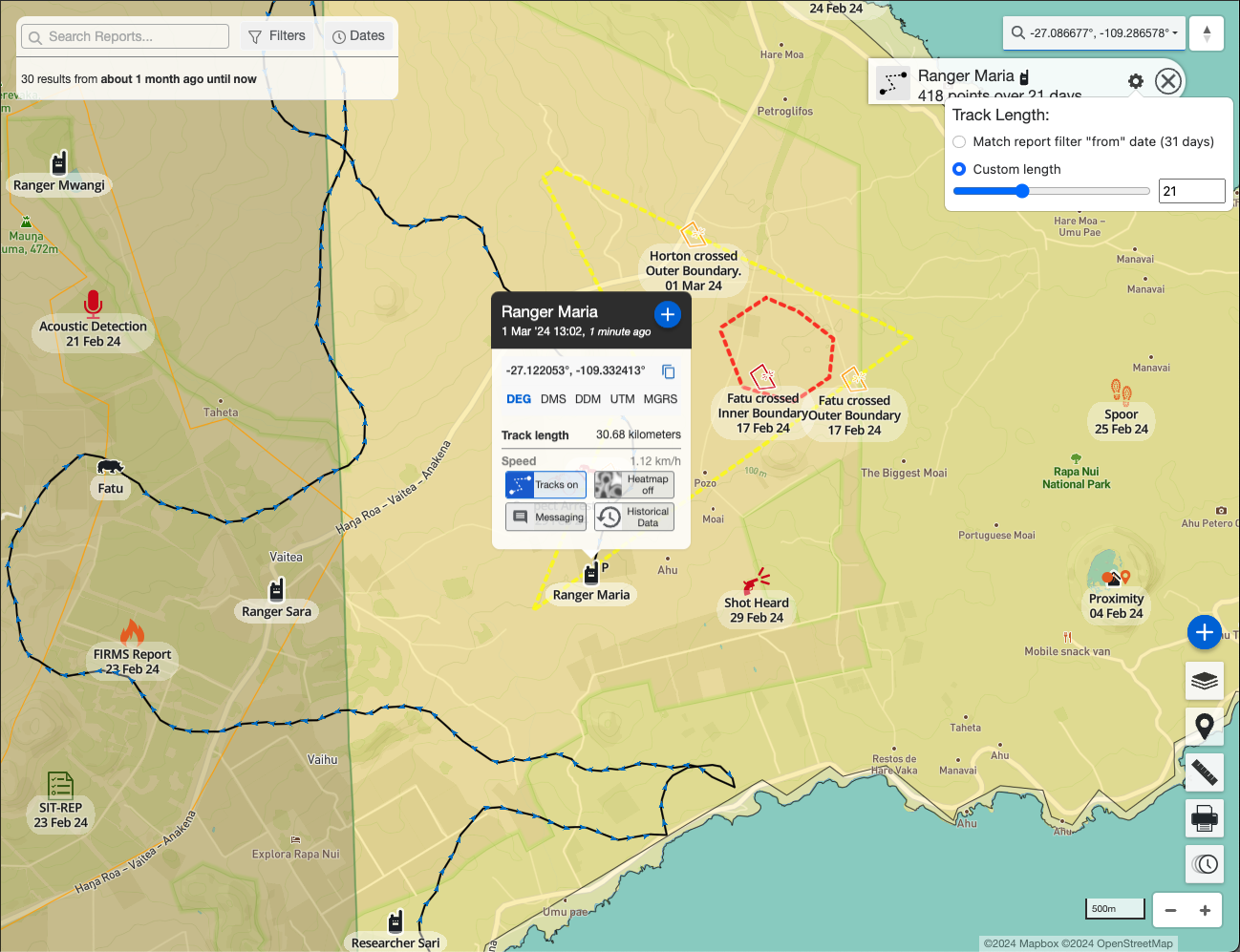
| Tracked Subject Properties | View the properties of the selected subject such as location, the date of the most recent update, and enable the tracks or the heatmap of the subject. This could include Rangers, Tracked Subjects, Subjects, etc. |
| Tracks Button | Display the tracks the subject has recorded. It has three states starting with the “Tracks off” where the tracks are invisible, when clicked, the button will change to “Tracks on” making them visible and displayed on the map. When clicked again, they will change to “Tracks pinned” and stay visible on the map even if you close the Tracked Subject Properties. |
| Heatmap Button | Heatmaps can be activated and deactivated to be visible on the map from the Tracked Subject Properties. |
| Cluster | Refers to a grouping or concentration of data points on the map. These data points may represent various events, observations, or incidents that have occurred in a specific geographical area. |
| Tracks | A line visualizing the recorded movement of a subject over a period of time, drawn by connecting its observation points in chronological order. |
| Geofence Warning Fence | A virtual boundary set up around a geographic area, where an alert of warning is triggered when a device enters or exits this predefined zone. |
| Geofence Critical Fence | A virtual boundary set up, where a critical alert is triggered when a device enters or exits this predefined zone. |
| Boundaries | Delimitations of certain areas on the map. |
| Heatmaps | Heatmaps are colored circles that show the location and the intensity of their associated events. |
| Tracked by | Represents the device that is being tracked on a Patrol. |
| Reported by | Represents the user who created an event. |
