You can configure your personal preferences for using EarthRanger under the Settings tab on the left-hand Side Bar Navigation.

General Settings
The General Settings section lets you personalize how EarthRanger behaves and displays information. These settings are found under the Settings tab in the left-hand sidebar. Use them to create a consistent experience that matches your specific monitoring and analysis needs.

App Refresh Settings
The App Refresh feature controls how EarthRanger preserves your workspace when the page is refreshed or reopened in the same browser session.
Starting with the latest update, App Refresh is enabled by default, meaning your map position and zoom level, event filters, patrol filters, and map layers will now automatically remain the same after reloading the page.
This change helps you maintain context as you move between tabs or refresh during long sessions, without needing to reapply filters or reposition the map.
Preserved by Default
- When App Refresh is active (default), EarthRanger remembers:
- Map Position & Zoom Level – Keeps your last viewed area centered and scaled.
- Event Filters – Continues focusing on your selected incident types after a refresh.
- Patrol Filters – Maintains your patrol view preferences to save time.
- Map Layers – Keeps the same layers visible or hidden based on your last session.
- Adjusting Your App Refresh Preferences
- If you prefer the previous behavior — where EarthRanger resets these settings after a refresh — you can adjust this in Settings:
- Go to Settings → General.
- Under App Refresh, unselect the options you don’t want to persist.
- EarthRanger will then revert to resetting those elements each time the page reloads.
- Tip: These settings are especially useful for users who monitor consistent regions or work through extended control room shifts.
Experimental Features
Try out beta functionalities designed to enhance usability and performance.
- Toggle experimental features directly in this section.
- Expect updates—these features may evolve or be removed based on feedback.
Map Settings
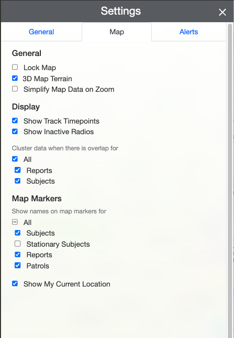
These settings give you greater control over how data appears on the map.
General
- Lock Map – Prevent accidental map movement.
- 3D Map Terrain – Toggle terrain visualization for more topographic context.
- Simplify Map Data on Zoom – Reduce map clutter by summarizing features at high zoom levels.
Display
- Show Track Timepoints – View individual location updates in tracks.
- Show Inactive Radios – Enable this if you need visibility into offline or inactive subjects.
-
Cluster Data When There Is Overlap For:
- All – Cluster all types of data.
- Reports – Only cluster report icons.
- Subjects – Only cluster subject icons.
Map Markers
-
Show Names on Map Markers For:
- All – Show labels for everything.
- Subjects – Label tracked devices only.
- Stationary Subjects – Useful for static installations like cameras or gates.
- Reports – See quick context at a glance.
- Patrols – View patrol labels on the go.
Location Display
- Show My Current Location – Useful for users in the field or teams validating location-based incidents.
Alerts
To set up or manage Alerts, visit:
How to use Alerts and Notifications - Video
These links will walk you through managing incident-based notifications tied to your site’s needs.
Up Next: Adding Map Quicklinks in EarthRanger Admin